JavaScript is disabled
Our website requires JavaScript to function properly. For a better experience, please enable JavaScript in your browser settings before proceeding.
I have a permanent year round creek at the bottom of my property, but it is about a thousand feet away, and is several hundred feet lower than my house. It's flow is several times greater in the winter - the one thing we don't lack here on the mountain is rain. It just crosses a corner of my property, so it doesn't cause problems - the only crop I have is trees and I can't log within 100' of a permanent creek like that.

But it is a water source - one that I could use if necessary - I would have to filter it though. I have a well, and as long as I can provide it with electricity then I have water.
 
I imagine the corps of engineers will have time in the front.
Not sure what you mean by that statement, since neither the Edenville Dam nor the Sanford Dam was built nor owned by the USACOE.

Not all dams built in the US are Corps dams, despite the fact that that is what most people associate with the organization.

ETA: There has never been a dam failure in the United states where the dam was designed or constructed by the USACOE.
 
Last Edited:
Probably no reason to mention here that according to all the "news" channels in Oregon....we are in a drought. Maybe even a "mega-drought".

Yet we have flooding (over-running of river and creeks into flood plains) - somewhat (I have lived off and on in this area for 60+ years and I notice the local flooding); less the last couple of years - it still floods, but not as much and for not as long.

Yes, we have a drought going on due to weather pattern changes (*cough* climate change for those of you who are not in denial *cough*).

Most of Orygun is in that drought - except for the NW corner (from about Newberg up to Astoria) which has normal rainfall the closer you get to the coast. I have about twice the rainfall that the valley gets (which the latter is still almost 10" down from normal) so I am fine up here - I could do with less rain, but most of it runs off down into the valley anyway.

April and May have been wet for me this year; last year I was burning slash piles in April and had to stop because it got too dry to safely burn, then I had to spend most of the rest of the year putting out small fires, this year it is too wet and muddy to get back there and do any work. Going to have to wait for June.

The summers are drier than in the past - I could remember when we would take bets on whether it would rain on July 4th and half the time we would lose and it would rain, farmers would fret that they would get too much rain to harvest crops, that the rain would split the cherries and ruin the tomatoes, make the grass seed and hay too wet to harvest - now we take it for granted that June, July and especially August, then September will be dry months.

Now farmers are increasingly irrigating crops and worrying about it being too dry. Loggers/tree farms like mine are worried about fire danger.

Look at the fires we have had - last year at this time we had numerous fires. We had some last month, but not this month (I think) - some field fires during dry weeks.

The big problem is not the reservoirs or the rivers, the big problem is the aquifers are being drawn down by the cities and the farms. Those aquifers will take centuries to refill - IF we stopped drawing them down tomorrow, which isn't going to happen. So yeah, we are in a water crisis, and it isn't just about the weather/rain - it is about the number of people for the amount of water we have - too many people, and that is only getting worse.

At some point, people will be fighting about water and food and other natural resources. They already are in other countries.
 
My grandfather was an Army Engineer and worked on dam projects from Bonneville to Hills Creek. On the last one, Hills Creek is the one I remember most as I was 7 when he started working on it. Competed in 1961 it is now 59 years old. I remember a few years back reading it was in the area of ancient slides and if a large earthquake occured the mountainside could slide in reservoir and cause the water over top the dam, destrying it in the process. It would set off a chain reaction that would over top North Fork and Dexter Dams . It said that Eugene and all areas downstream would be catastrophically flooded. It didn''t say much about the effect it would have downriver from Eugene, but I image there would be massive flooding also. On the Columbia all it would take is for Grand Coulee to fail and I assume all the other dams downstream would fail also. This probably has a more damaging outcome for Portland than the Willamette Valley flooding, although neither one is very good. All the dams on the Willamette and Columbia Rivers need repair and maintenance work that has been neglected for years. To ignore this is to invite a catastophe of monumental proportions. I agree with other posters instead printing money like it was going out of style invest in the infrastructure of our country, and put people to work.
 
Neighbor works for the Corps - on various dams, the power gen specifically. I haven't heard anything about the structures specifically or any complaints, but the structures are not his domain.

My dad worked on some of the dams as I recall, but I was too young to know which or remember, and both my parents are gone now so I can't ask.

But I have been around a number of those dams when I was in the USCG - working aids to navigation. I remember putting in a boat in the reservoir behind Grand Coulee (a truly massive dam); with the front of the boat still on the trailer the fathometer read 600' feet at the transom, but it went around twice so I assume that meant 1200', so quite a drop off (it was very steep where we put in) and that was when the water was down during the spring (we took out the buoys in the late fall and put them back in the early spring when the water was down - which meant sometimes dragging a very heavy buoy up an embankment).

My point is, there is a LARGE volume of water behind that dam (the Roosevelt reservoir). I went as far up the Columbia you can go in a small I/O boat - up past China Flats - we didn't want to go too much further or we would cross the border and it was getting shallow.

The Spokane river did have a landslide where it caused a huge wave and blocked the river for a while, but that was decades ago - I saw where that was. Very steep cliffs up that river near the confluence with the Columbia - that was fun going up it in an I/O boat - we got stuck on rocks several times.

But I don't worry much about the Columbia river dams - I have read that they are all fine with regards to an earthquake. It is the smaller dams like the one you described that are problematic from what I have read.
 
My father was also a USACOE engineer for decades until he retired completely in 1991. He worked on the design side (from the very early 1960s) and later the construction side (from the mid-1970s) on all four COE dams on the lower Snake River and many on the Columbia, out of the Walla Walla District. I toured many of these locks and dams with him as a young kid. No USACOE dam has ever failed.
 
My father was also a USACOE engineer for decades until he retired completely in 1991. He worked on the design side (from the very early 1960s) and later the construction side (from the mid-1970s) on all four COE dams on the lower Snake River and many on the Columbia, out of the Walla Walla District. I toured many of these locks and dams with him as a young kid. No USACOE dam has ever failed.

Yup - been on the Snake too. Very cold the winter of '78 - the Columbia froze over at Kennewick. Good memories of my duty there. Bad memories of my off-duty time (I separated from my wife and missed my daughter terribly).
 
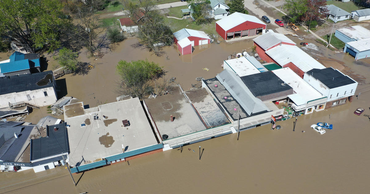
Heard on the news this AM that it was a 500 year flood event. How is it a 500 year event when it is a dam failure?
Sounds to me like it was a flood first that caused the dam failure.

From Wikipedia:
On May 19, 2020, 5:46 p.m., due to flooding on the Tittabawassee River, the eastern side of the dam collapsed, prompting immediate evacuations in the town of Edenville and the city of Midland. The Sanford Dam, about 10 miles (16 km) downstream of the Edenville Dam and six miles (9.7 km) upstream of the city of Midland, subsequently overflowed.[24]
 
Would seem to be the failure to address capacity concerns.
 
Neighbor works for the Corps - on various dams, the power gen specifically. I haven't heard anything about the structures specifically or any complaints, but the structures are not his domain.

My dad worked on some of the dams as I recall, but I was too young to know which or remember, and both my parents are gone now so I can't ask.

But I have been around a number of those dams when I was in the USCG - working aids to navigation. I remember putting in a boat in the reservoir behind Grand Coulee (a truly massive dam); with the front of the boat still on the trailer the fathometer read 600' feet at the transom, but it went around twice so I assume that meant 1200', so quite a drop off (it was very steep where we put in) and that was when the water was down during the spring (we took out the buoys in the late fall and put them back in the early spring when the water was down - which meant sometimes dragging a very heavy buoy up an embankment).

My point is, there is a LARGE volume of water behind that dam (the Roosevelt reservoir). I went as far up the Columbia you can go in a small I/O boat - up past China Flats - we didn't want to go too much further or we would cross the border and it was getting shallow.

The Spokane river did have a landslide where it caused a huge wave and blocked the river for a while, but that was decades ago - I saw where that was. Very steep cliffs up that river near the confluence with the Columbia - that was fun going up it in an I/O boat - we got stuck on rocks several times.

But I don't worry much about the Columbia river dams - I have read that they are all fine with regards to an earthquake. It is the smaller dams like the one you described that are problematic from what I have read.

If those columbian Dams did fail, how high would the water rise? Same question on the Lewis river dams....

Would Vancouver flood? I am about 100' elevation.
 
Very likely not. The last dam on the Columbia is Bonneville. The water behind Bonneville would just run to the ocean (no impoundment downstream).
If there were a dam below you, then you would be in trouble cuz they likely couldn't draw down the lake behind it fast enough to prevent overtopping.
There would have to be a whole helluva lot of dam breaks behind Bonneville to endanger you, like, just about all of them would need to fail in succession.
Very unlikely...

In my brief research, it sounds like Bonnivilles gateways are in bad shape, and would not be able to release enough water to deal with a 500 year event.

Does that change things, if Bonniville outright fails due to flooding upstream?

My bigger concern is the dams on the Lewis river I think....lots of water up there with lots of elevation.
 

Upcoming Events

Centralia Gun Show
Centralia, WA
Klamath Falls gun show
Klamath Falls, OR
Oregon Arms Collectors April 2024 Gun Show
Portland, OR
Albany Gun Show
Albany, OR

New Resource Reviews

New Classified Ads

Back Top