JavaScript is disabled
Our website requires JavaScript to function properly. For a better experience, please enable JavaScript in your browser settings before proceeding.
Messages
42,795
Reactions
111,141
When I was young, there were a number of ways to get over the Cascades and the coastal range in Orygun without using main paved roads, maybe not so much now with land closures?

I know when I lived in the Seattle area, it was very difficult to legally traverse from Seattle to eastern Washington without going over on main public roads - due to watersheds/etc. being closed (IIRC at least one of the watersheds is patrolled and the occasional trespasser arrested).

When I was stationed at Newport I sometimes would come into the valley via Valsetz - but is that road is closed now with the town gone?

I used to ride dirt bikes in the Rickreall watershed, but that was closed last time I was out there.

Some guys I knew would ride along the Van Duzer corridor and up in the Grand Ronde area, and I vaguely recall that some of those logging roads went through.

IIRC some of the back/logging roads over the Cascades, both from Salem and Eugene, used to go through to eastern Orygun.

Got to thinking about this when I saw this on FB:


How To Hike From Portland To The Oregon Coast
 
Last Edited:
Personal input. May not be accurate. Subjective?

Excellent subject matter. I should be overhauling our Wildfire Vehicle Bug Out Bags but your questions have great merit. Can you join a local Jeep Club? Maybe also known as a motorized off road club? Off road bicycle clubs? How about a hiking or camping club? You need access to the "straight local scoop" regarding what is open ... what is closed ... what is still accessible. So on, so on.

Consider the Sheriff's Posse? Consider search and rescue?

New Topographic maps suck. Too politically correct. Sanitized. Very old topo maps are valuable and copyable. Old maps show trails, access roads, egress roads, EASEMENTS, springs, old mines, logging roads, etc.. The new topo maps do not. Lots of recent road closures. You also can consider asking local fire officials but they will not say. You need to get inside local recreational infrastructure.

Aircraft pilot FFA maps are great. Show lots of stuff. Utility access maps. Power lines, buried cable and big pipe.

Then ... walk the walk. The only way one can determine if alternate escape routes from death areas like large or small urban areas is to actually scout them out yourself. Lots of areas will be closed to all motorized vehicles. Hiking may be your only way of getting in to see for yourself. Bicycle? THEN make several plans. Having buddies is good. Then equip your vehicles with the needful things.

Chain saws. Big bolt cutters. Small cutting torches. All probably illegal in some sort of fashion now, but after the SHTF possession may not make any difference. Remember conditions will change quickly. Wildfires. Landslides. Flooding conditions.Too may other desperate people. Thirsty. Hungry. Scared. No gasoline. Be very careful. Do no harm. You have the right of LIBERTY.

LIBERTY in this case the old definition of freedom of travel or even movement, particularly after the SHTF. Remember that good prior planning and training will make a nasty situation for others just another training day of fun for you. An oversimplification but there you have it. We also right now are dusting off old plans and escape routes out of the Illinois Valley SW OR. Wildfire season.

Respectfully.
 
Some sharp spurs and a tauntaun and yer all set!

databank_tauntaun_01_169_b7307446.jpe
 
I have two 4x4s and an AWD commuter car, but I learned over the years that they are expensive to maintain when you take them off-road, not to mention make them more capable - so I switched to dirt bikes.

Problem is I am having problems with my back which makes it hard to ride. Once I get some property work done I am going to try riding again, but I may wind up selling them. Otherwise, if a person is able, my recommendation is a dirt bike for exploring.
 
A buddy and I tried to get from Hagg lake to Tillamook via gravel a couple months ago. Lots of routes look good on a map but are not actually passable. We found a couple promising routes posted on my bike forums (We were on motorcycles) but even those were closed.
There's a lot of roads with big locked gates across them.
 
Chain saws. Big bolt cutters. Small cutting torches. All probably illegal in some sort of fashion now, but after the SHTF possession may not make any difference. Remember conditions will change quickly. Wildfires. Landslides. Flooding conditions.Too may other desperate people. Thirsty. Hungry. Scared. No gasoline. Be very careful. Do no harm. You have the right of LIBERTY.

Battery operated cutoff saw for those gates with chains/cables/locks/etc.
 
A buddy and I tried to get from Hagg lake to Tillamook via gravel a couple months ago. Lots of routes look good on a map but are not actually passable. We found a couple promising routes posted on my bike forums (We were on motorcycles) but even those were closed.
There's a lot of roads with big locked gates across them.

It's because of population. The damage/vandalism/fires caused by bad people used to be manageable, but it got to the point where there was just too much. Then there is the issue of liability.

The only way to know for sure is to get out there and explore.
 
I've said it before and I'll say it again; if sh!t goes sideways, you'd better already be where you need to be. Bugging out of an urban area will be next to impossible. Getting from coast to valley or valley to east side will be really tough.
 
I've said it before and I'll say it again; if sh!t goes sideways, you'd better already be where you need to be. Bugging out of an urban area will be next to impossible. Getting from coast to valley or valley to east side will be really tough.
:eek:

Vehicle travel on unsecure routes will be risky in a post shtf scenario. 4 vehicles minimum; lead veh is security, 2nd is nav, 3rd is C2, and 4th is rear security.

I seen that same program on routes accross the coast range. It brings to mind X, Y, and Z in route classification. Aka Go, Slow-Go, and No-Go.

There will be combat power to be projected on all routes....
 
I've said it before and I'll say it again; if sh!t goes sideways, you'd better already be where you need to be. Bugging out of an urban area will be next to impossible. Getting from coast to valley or valley to east side will be really tough.

I already live at my BOL on 20 forested acres on a mountain outside of any urban area - more than rural, mostly forested with some vineyards and pastures and hay fields.

But it is always good to have a backup plan. You might be visiting the coast or be skiing at Bachelor when an earthquake happens. It would be good to have an alternate route or three to get home. I have more than once had to take a detour because of really really bad traffic - a couple of times hundreds of miles out of my way.

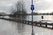
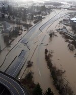
I-5 during one winter:

2087157613_2531935006_b.jpg
2018993826-780x0.jpg
 
Trial bikes. We were into them years ago. Better than a tight woods enduro bike but harder to carry meaningful fuel. For the young whippersnappers a good trail bike. Or just plain old humping back packing.

Regarding motor cycles, years ago I had a 1972, (?) Taco Alpine a 250. Four, (4) gallon gas tank. Bigger seat. Geared way down. Worked both ways as a tight woods bike and a fairly good starter trials bike.

Our situation here in SW OR USA this time of year is wild fires. Very fast moving. Therefore right now and because of our advanced age, infirmed medical conditions and suspect mental states, SUV cars work.
 
Having made a couple of 'over the crest via a secret mountain trail' journeys in the past in a suitable 4x4, I'm gonna make a flat out prediction that IF such need ever came to be, in the situation of depleted physical capacity, limited suitable gear, and no actual real action plan once I DID make it across, such would be a foolish mistake.

I once traversed the crest across the Rockies at the famed 'Lost Trail Pass' of Lewis & Clark, from east to west....'the EASY way' mostly downhill....severe switchbacks, washed out spots, off camber gravel slides, steep spots & dead blind corners where often the route was of considerable doubt.... I had a local guide there to thank for it. Some day I'll catch up with him & see he gets his reward.....

I also traveled a non-paved route across the Pacific Crest range, and discovered a charming lake & very small campground, used for generations from the looks of it. Both of these in the strictest sense could have been negotiated with horses, dirt machines or 4x4. Neither would have been pleasant hiking, even to escape the Great Zombie Tribe on your tail.

I'll have to make other plans.
 
Chain saws. Big bolt cutters. Small cutting torches. All probably illegal in some sort of fashion now, but after the SHTF possession may not make any difference. Remember conditions will change quickly. Wildfires. Landslides. Flooding conditions.Too may other desperate people. Thirsty. Hungry. Scared. No gasoline. Be very careful. Do no harm. You have the right of LIBERTY.

Good questions, and good ideas.
As @Oathkeeper1775 suggested, you need a secured convoy strategy.
I think a bare minimum of equipment will be this:
  1. A serious, lifted OHV, one you can use for mudding. Problem then is fuel. There's going to be a lot of LO traveling, and it will consume lots of fuel. Need many storage tanks to boot.
  2. Bolt Cutters, gas powered chop saw, 36" chain saw, spare chains.
  3. Chains, hooks, powered winch and come-alongs.
  4. [edit to add] shovels and tire chains.
  5. A well planned, well prepared map.
Some speculative thoughts, assuming the SHTF situation is truly a breakdown of society and not a local disaster:
The Good
I did a Coast to Willamette Valley in the Siuslaw back in spring 2008, not by intention. Didn't have a chain saw and really needed one. Lots of closed roads then too. I also have seen a lot of new roads. IMO, the maintained forest backbone roads are the ones to learn well first. They are the ones to get you through, and the shortcuts between them are the avenues you need to know to make that traverse. [edit to add] A lot of those short cuts are overgrown two-trackers, where you may need to saw out some fall and clear a dozer hump or two.
If you have the health, I recommend mountain biking for your research - you see more options moving slower.
I've discovered old roads that have been closed for decades, some for mining, most for logging. No longer useful for vehicles, but they are pathways for faster egress than directly through the woods, and IMO more defensible if you are stuck on foot.
The Ugly
I see way more blocked off roads and locked gates than before. Getting over the Cascades will be harder.
I also think, it the SHTF is the result of a >8.5 earthquake, many of these roads are going to be either gone, covered, or very difficult to pass due to tree falls. In this case, I think it would be beneficial to know the watershed.
The Bad
In every section of this great PNW where I crawl around, I have met up with a handful of locals who know the area like the back of their hand. Problem is, some of those I've met know it that way because they are living on the edge, and there's food to be had in those hills. They also seem to me to be the type who will be waiting for suckers who are looking for a way through.
 
Last Edited:

Upcoming Events

Lakeview Spring Gun Show
Lakeview, OR
Albany Gun Show
Albany, OR
Falcon Gun Show - Classic Gun & Knife Show
Stanwood, WA
Wes Knodel Gun & Knife Show - Albany
Albany, OR

New Resource Reviews

New Classified Ads

Back Top