- Messages
- 201
- Reactions
- 33
- Ad Type
- For Sale
- Price
- $35000
- City
- Orondo
- State
- Washington
- Zip Code
- 98843
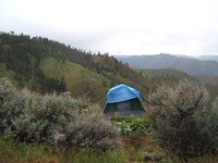
Selling my off-grid remote hunting land, owned this for 13 years and bought it from a fellow member on here. I go up for fall Mule Deer season mostly, it has a spring fed creek that runs through at the bottom of the valley, I've cleared an area for parking and setting up a tent. The nice part about this is the gated access, don't have random people coming through. Road and gate are maintained by the property owner's association $75 a year. I've left stuff there over the years and never had any problems with theft or anything.
Requires a key for access, and I'm in the process of moving back east so need to find a realtor to give access or possibly meet up when I'm back in June or July.
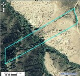
MAP LINK: http://douglaswa.mapsifter.com/default.aspx?parcel=53600000100
Property Info
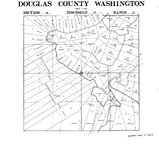
If you use http://maps.google.com/ and enter " 47.620984,-120.175152 " you will find the center of the property at the creek. This is Lot 1 of Deer Creek Division B. Can also be found using "Tyee View Loop Road, Orondo, WA" but this doesn't place the property, only general location. Click on Satellite to get better idea of terrain.
Douglas County
Parcel#: 53600000100
DOR Code: 18 - Residential - All other
Situs: TYEE VIEW LOOP, Orondo, WA 98843
Map Number: 2521-35-32-000536-000-00001
Property Taxes $153.78
Description: LOT 1; DEER CREEK B
Comment: 05/03-ZONED RURAL RESOURCE 5
District: 248 - 209-F1-H2 (ST;CO;PORT;RD;LIB
Current Use/DFL: No
POA Fees: $75
Total Acres: 11.65000
 douglaswa.mapsifter.com


Requires a key for access, and I'm in the process of moving back east so need to find a realtor to give access or possibly meet up when I'm back in June or July.
MAP LINK: http://douglaswa.mapsifter.com/default.aspx?parcel=53600000100
Property Info
- 11.65 Acres on Badger Mountain, about 2+ acres of flat usable area near the road for building a cabin, cleared area for parking/camping. 335' Wide x 1690' Long.
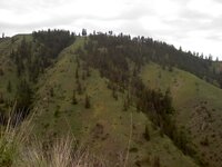
- Property borders BLM land. Mix of trees and brush and open, great views and quiet serenity.
- Great area for hunting, that's all I've used it for. White-Tailed or Mule Deer, Bear, and Elk in the area, plus Turkey and grouse as well. GMU 266 Badger, (P20- for Turkey)
- Secure gate access from 2 locations, main access road off HWY2 a few miles out of Orondo, WA. Has high security key to unlock or you can get a key fob that simplifies access with automatic gate for $100.
- Active POA: DeerCreek87 Property Association, dues are $75 a year and cover road and gate maintenance, usually the active members are owners living on the properties there. The website has more info: deercreek87.org
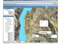
- No restrictions about using a creek as a water source. This creek is fed by a spring and flow depends on the summer sometimes is very small, but The "main water table" is about 100 feet down even less. When and only when creek dries up you can dig a hole at the most 5 feet and you will have water - I did this in a middle of hot summer. We always bring in a 50-gallon drum for potable water, but many others with cabins filter rainwater or have a cistern filled.
- Community well is about 1-1/2 to 2 miles back towards entrance.
One of the property owners nearby drilled a well on the top of parcel # 4 or 5 and hit the water table around 120 feet down.
- The quickest way to get to the 12 acres is to use the gate right of the highway 2 about 1/2 mile from Orondo, again you need a key to get to it.
If you use http://maps.google.com/ and enter " 47.620984,-120.175152 " you will find the center of the property at the creek. This is Lot 1 of Deer Creek Division B. Can also be found using "Tyee View Loop Road, Orondo, WA" but this doesn't place the property, only general location. Click on Satellite to get better idea of terrain.
Douglas County
Parcel#: 53600000100
DOR Code: 18 - Residential - All other
Situs: TYEE VIEW LOOP, Orondo, WA 98843
Map Number: 2521-35-32-000536-000-00001
Property Taxes $153.78
Description: LOT 1; DEER CREEK B
Comment: 05/03-ZONED RURAL RESOURCE 5
District: 248 - 209-F1-H2 (ST;CO;PORT;RD;LIB
Current Use/DFL: No
POA Fees: $75
Total Acres: 11.65000
Disclaimer
 douglaswa.mapsifter.com
- I agree to the classified rules and terms of service


