JavaScript is disabled
Our website requires JavaScript to function properly. For a better experience, please enable JavaScript in your browser settings before proceeding.
I think generally most outdoor stores carry those? - i want to say, haven't looked for any myself. If not that you could probably find one at a city hall or perhaps the oregon fish and wildlife.

You could probably find a topomap online and have something like kinkos print one out for you too.

Oregon Butte Topo Map, Columbia County WA (Oregon Butte Area) From my understanding you can also use E-maps on the mobile. Probably best to download it and set it to offline use.
Found this while searching online, seems useful Oregon DeLorme Atlas: Road Maps, Topography and More!
 
Last Edited:
Back when REI was more worried about outdoor recreation then virtue signalling to people who never get their boots muddy I used to get my topo maps there. You should be able to get them at Cabelas or Sportsmans.
 
What will you use them for?
What area do you need them to cover?

For on-trail hiking, the Green Trails maps are OK. REI used to sell them, not sure if they do now or not:
Buy Map

Oregon Mountain Community may have some - give 'em a call:
OMCgear - Search results for: 'green trails maps'

For off-trail climbs, etc, I prefer the greater detail of USGS topos, but I don't know who has those any more, or if they are available at all. Looks like the USGS may sell them - take a peek:
https://www.usgs.gov/undefined

Maps | USGS Store

Those Delorme Atlas books mentioned by E4mafia above are great for driving back roads.

EDIT: Call the local USFS ranger - ask what they have.
 
Last Edited:
Back when I spent most of my off time backpacking and hiking I also used to make sure that I treated the map with a waterproofer/sealer. The one I used is called mapseal, but there are other products as well.
 
  1. I download all mine, use them on a tablet, offline.
  2. For specific wilderness areas, like Tillamook State Forest / Mt Hood / Jefferson Park, etc, there are published maps you can get at the ranger's office that are some of the best, including foot trails. They are already waterproof.
  3. The Delorme topographic map book is useful for backup, but is scant on detail.
 
The wife and I bought most of ours at our local backpacking store. I also get some from the US Forest Circus office. And my local gun shop carries some.
 
Good advise up there^^^^^.

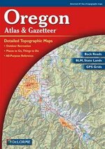
In addition, couple more things to add. I've bought full Delorme books for both Oregon and Washington. They slide into the pocket on the back of the vehicle seat and stay out of the way. So sweet when you need one to have it for where ever you are and you can pop it out, flip a few pages and find your way. Looks like this:

th?id=OIP.jpg


Here's a link to get you started if you so choose. Oregon DeLorme Atlas: Road Maps, Topography and More! they are smaller than the USGS stuff, but easy to store and available when you drive too far and need the next topo over:) I don't recall paying $25 each, look around you may find cheaper.

I will note that the Gaia ap will do the same thing, except on a smart phone, much better and cheaper (as long as you have battery life). It will tell you where you are and where you are heading. (and how far you've walked etc etc). https://www.gaiagps.com/
I haven't used a topo since I bought the Gaia Ap. I have the basic one, and it really works good for what I want to do. Worth looking at for sure. If you don't think you'll have internet (you won't) you download the maps for those areas you want in advance and it uses the GPS satellites and your phones nav system. Good stuff.

Good luck!
 
Good advise up there^^^^^.

In addition, couple more things to add. I've bought full Delorme books for both Oregon and Washington. They slide into the pocket on the back of the vehicle seat and stay out of the way. So sweet when you need one to have it for where ever you are and you can pop it out, flip a few pages and find your way. Looks like this:

View attachment 526363


Here's a link to get you started if you so choose. Oregon DeLorme Atlas: Road Maps, Topography and More! they are smaller than the USGS stuff, but easy to store and available when you drive too far and need the next topo over:) I don't recall paying $25 each, look around you may find cheaper.

I will note that the Gaia ap will do the same thing, except on a smart phone, much better and cheaper (as long as you have battery life). It will tell you where you are and where you are heading. (and how far you've walked etc etc). https://www.gaiagps.com/
I haven't used a topo since I bought the Gaia Ap. I have the basic one, and it really works good for what I want to do. Worth looking at for sure. If you don't think you'll have internet (you won't) you download the maps for those areas you want in advance and it uses the GPS satellites and your phones nav system. Good stuff.

Good luck!


I used to be all about Delorme, until I recently discovered Benchmark maps. So much more detail, especially in remote areas. You should give them a gander. I actually think they both have their pros and will make a good team.
 
Another +1 for the Delorme Atlas & Gazetteer maps. Super handy.

Also another +1 for USGS quads. As mentioned, give a call to your nearest Forest Service office, or if you ever get down to Salem the Main Oregon Forestry office (off State street, across from the state prison) had a bunch a few years back when we needed some.
 
I usually buy mine at forestry centers and ranger stations, but those usually only cover or are offered for the region managed by those offices.
I think there are more options if you go to HQ for the land type you are looking to explore (BLM, Parks/Forestry, USGS).

Somebody posted a pretty cool link in another thread, sorry I can't credit them.
Hillmap - Backcountry Maps for the Obsessed


PS: also never had any trouble using Delorme Atlas and Gazetteer. Useful to keep under the carseat... right next to the entrenching tool and first aid.
 
Found another source - scroll down to "Printed Maps" and check out "My Topo":

Wilderness.net - Maps

MyTopo (Prints custom topographic or aerial photographic maps that you create through their online interface and mails them to you next-day. Choose the location, size, resolution, paper type, and other map attributes like flat or folded. This is a much cheaper option than purchasing individual USGS quads and the maps are extremely high quality.)
MyTopo | Custom Topo Maps, Aerial Photos, Online Maps, and Map Software
 

Upcoming Events

Redmond Gun Show
Redmond, OR
Klamath Falls gun show
Klamath Falls, OR
Centralia Gun Show
Centralia, WA

New Resource Reviews

New Classified Ads

Back Top