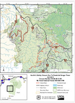
JavaScript is disabled
Our website requires JavaScript to function properly. For a better experience, please enable JavaScript in your browser settings before proceeding.
I never saw this anywhere. Where did you get this from? Link? I see nothing in current or past MHNF alerts. Wildfire season closure, sure. Clackamas River Ranger District has closed off a larger area to target shooting, not the entire Mt Hood National Forest. Check with specific ranger districts as to their closure areas.
Wildcat is the only spot in mh.
 
It seems like the USFS is giving conflicting information- or I'm confused, which is always a possibility- but this map makes it look like Wildcat is closed as well?

https://www.fs.usda.gov/Internet/FSE_DOCUMENTS/stelprdb5423087.pdf
Yo Daniel,

Here's a good idea where the shooting area is, in relation to the Closure area. The shooting area is the RED STAR.
Closure area at Wildcat Mtn Showing Shooting Area.jpg
It helps when if USFS would have put the road name on their map (NF36). At least they put the Wildcat Mtn Gravel Pit on it, but they don't show the WC Mtn Trailhead Parking area. So, I put some notes, in RED, so you can identify where things are.

Here's a map you can zoom in to find a place (it's only public land places): https://www.trashnoland.org/map-of-places-to-shoot/
 
This is the most recent closure map. It is labeled by National Forest Service Road numbers. The main black and white road down the middle is HWY 224 which becomes 46 road at Ripplebrook. The only new one not listed yet is the 4640 road. That is a green wildlife gate closed from Dec 1 to Apr 1, but there is a contract coming up to remove hazard trees (from the Riverside fire) on that road so it will remain closed for a few more months. The 57 road is scheduled to begin contract work this summer for hazard trees and some rock slide mitigation.
 

Attachments

  • 47875177-0106-47D0-8BB6-DC22940E3627.jpeg
    47875177-0106-47D0-8BB6-DC22940E3627.jpeg
    849.5 KB · Views: 66
Yo Daniel,

Here's a good idea where the shooting area is, in relation to the Closure area. The shooting area is the RED STAR.
View attachment 1415623
It helps when if USFS would have put the road name on their map (NF36). At least they put the Wildcat Mtn Gravel Pit on it, but they don't show the WC Mtn Trailhead Parking area. So, I put some notes, in RED, so you can identify where things are.

Here's a map you can zoom in to find a place (it's only public land places): https://www.trashnoland.org/map-of-places-to-shoot/
Fantastic info, thanks so much! I haven't been up in that part of the forest to shoot for 20 years, and I thought the pit was the spot.
 
Fantastic info, thanks so much! I haven't been up in that part of the forest to shoot for 20 years, and I thought the pit was the spot.
Well, it's not the best spot, due to the really small backstops, (so keep your targets low to the ground so bullets don't zip off into the forest beyond), but it seems to be the only place in Mt Hood NF where we can shoot. Id like to dump another pile of dirt on that backstop, but that would take some doing.

If you go, take note of the conditions and let us know what the place looks like. Lots of trash? Graffiti on the rocks? Any backstop at all left? Any trees left standing?

Thanks,

Bill
 
Yo Daniel,

Here's a good idea where the shooting area is, in relation to the Closure area. The shooting area is the RED STAR.
View attachment 1415623
It helps when if USFS would have put the road name on their map (NF36). At least they put the Wildcat Mtn Gravel Pit on it, but they don't show the WC Mtn Trailhead Parking area. So, I put some notes, in RED, so you can identify where things are.

Here's a map you can zoom in to find a place (it's only public land places): https://www.trashnoland.org/map-of-places-to-shoot/
Green pin is near the shooting spot you marked. Its off the 2609 spur.

1E652FBA-6F95-4C04-B348-44CE4BE8B3EE.png
 
All great but, still a bunch of snow at the top of Wildcat Mt. where the road starts gets narrow. Just past the OK to shoot sign. I did see at least three groups of people shooting lower down in the "No Shooting" zone. :(
I'm sure they were surprised as I to see the snow in the road.
Maybe in a few more weeks.
 
Went up Wildcat to find this place a few a weeks ago, as far as the snow line. About 7 miles past the upscale newer housing.
All I found was locked gates surrounded by spent shells and other assorted crapola on the road. (not even a prius)
Filled a bucket and didi mao'd.
Does anyone have a gate # so you know when you are getting close ?
 
Last Edited:
If the snow line was in the same spot as it was last time. Snow line was right where the road get narrow. The old beat up sign on the right of the road, says it's ok to shoot after that sign. You need to go a little past that sign where the road get narrow and take the next left turn.
 

Upcoming Events

Redmond Gun Show
Redmond, OR
Centralia Gun Show
Centralia, WA
Klamath Falls gun show
Klamath Falls, OR

New Resource Reviews

New Classified Ads

Back Top