JavaScript is disabled
Our website requires JavaScript to function properly. For a better experience, please enable JavaScript in your browser settings before proceeding.
I tend to really use the one in my head 1st. Then paper. Then I found this app called Gaia that is a godsend. After that, if I'm in front of the computer it's usually studying google earth or xmamps overlays.
 
I have a Garmin GPS with a bunch of different maps, but I still have paper. Pittman, USGS are probably my favorite, and a lot of ODF maps. I have a bunch of Jeppson aviation maps, still take them with me even with the Garmin. Too many years in Civil Air Patrol survival training and pilot survival training to depend on electronics. I have 2 sets working on 3 of Pitmann maps, one in my GHB of the 3 adjacent counties. I by them cheap at garage sales, and will just keep stacking them up, the wife can sell them for what I paid for them when I croak.

My boys like the GPS, but USGS are their favorite, similar to what they used in the military.
 
I'm starting to think Google maps and the others are somehow biased. Steering you away from or towards certain neighborhoods, towns or routes.

Trying to map out different/shortest cross country routes and getting a lot of variation.
I know shortest isn't always best but I'd bet politics and money are involved sometimes.
 
Google maps most of the time, occasionally Apple. I typically plan my own routes though, I don't typically like the routes the maps choose for me.
 
Google Maps. I'm on an iPhone 6s and I don't need to use the Apple Map.

Directions I use Waze.

I have a mild photographic memory and so really it doesn't matter what map I use for a street overlay.

I use Google Maps on the computer. That's why I go cross platform and use it on mobile. I find that it's nice to search for stuff on the computer and if I need quick recall on a mobile device that I'm signed into the recall is quick. No searching just start to enter it in and it pulls up recent history.

Seeing street view is also very important. That visual part of me trumps anything else.

I'm also damn good looking at a paper map and knowing a towns routes rather quickly. Working east coast and different towns every couple of months I had to adapt very fast.

I remember once being in Worchester (pronounced Woosta) and my step dad/boss drove is around the town and got lost. Stopped at a Boston Market by the time it was dark and then gave me the keys and said "ok I drove us to dinner now you get is back to the hotel." Visual memory came in handy. This was before maps and data usage was big on cell phone plans. Man I hated it when he would do that.
 
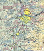
Kind of a tangent, but years ago when I was working on my pilot's license, I loved studying aeronautical charts/maps like the one below. I also love old maps, even collected a few prints of old maps.

image.jpeg
 
In the pick up i have a 1990 Thomas guide, Or. and Wa. Gazetter and various state and federal maps.

In the truck pretty much the same except for the Thomas guide, That got a new one back in 2002 i think. Generally i am good to go with a cross street.
 

Upcoming Events

Redmond Gun Show
Redmond, OR
Klamath Falls gun show
Klamath Falls, OR
Centralia Gun Show
Centralia, WA

New Resource Reviews

New Classified Ads

Back Top