JavaScript is disabled
Our website requires JavaScript to function properly. For a better experience, please enable JavaScript in your browser settings before proceeding.
Messages
312
Reactions
446
Thanks to all the members that helped me the first 3 days I've been here.
Found everything my wife and I needed and didn't get scalped.
She thought this might get a laugh here!

IMG_29241.jpg
 
I looked up a map of 'Newfoundland and Labrador'. Found a large circular lake/reservoir/island. Seems like few towns in huge landmass.
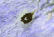
? No big cities as we understand it, except St Johns. Y'see, like much of Canada, it's pretty much empty of people - half the population of the tiny UK with a country second only to Russia in the size stakes. That island measures 42,030 square miles. The reservoir? If you mean the Smallwood Reservoir, well, I'd agree that it's quite big - 2250 square miles. It is the second-largest such facility in the world. So where is the circular lake? Guess you mean Mistastin Lake - abut twelve miles across - looks a bit like Crater Lake, eh?

1614617380990.png

You gots to remember that most of Canada is totally empty of anything except geography and topology and, at this time of year, snow.

A few years ago, whilst working in Japan, one of my students was looking at some imagery taken from space - LandSat-type stuff from NASA. His area of interest took him to Northern Canada in the Yukon/Alaska area and he was intrigued by what he saw a a shadow that spread across the landscape. From looking at sequential frames of imagery, each one with about 60 miles to the sides, it was clear that this amorphous discolouration was moving across the landscape at around ten-fifteen miles per day. What the heck was it?

It was a herd of around 80,000 - 100,000 caribou, the so-called Forty-mile herd.

The Fortymile Caribou Herd in Alaska and the Yukon is one of North America's most important migratory caribou herds, straddling the border of the US and Canada. It has been the focus of study for the past 60+ years in Canada and Alaska. In this NASA ABoVE affiliated project, PhD student Libby Ehlers is collaborating with the BLM, Alaska Department of Fish and Game, Yukon Fish and Wildlife, and the National Park Service to understand habitat and population dynamics for this important caribou herd. Recent growth of this herd to over 80,000 caribou has prompted this study on habitat relationships to assess whether the Fortymile Caribou Herd has approached nutritional carrying capacity and how that may affect habitat and vegetation dynamics.

Who knew?

Very few.

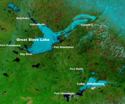
Ever heard of the Great Slave Lake?

Probably not, it's just about 10,000 square mile of water surrounded by Canadian scenery of outstanding beauty - the tenth largest lake on the planet.

1614618121509.png
 
Last Edited:
I went back to my search map <https://duckduckgo.com/?t=ffab&q=map+of+labrador+province&ia=maps&iaxm=maps> southwest of Happy Valley- Goose Bay .

"Reservoir Managuagin and Isle Rene Lavasseur" Due N of Baie-Comeau on shores of St. Lawrence River mouth. "Reservoir Manic 3" due N from shoreline about 1/2 way to 'Isle Rene Lavasseur' which is about the level of southern Labrador provincial boundary but W of it some distance. Anyone know much of this feature?
 
What do you want to know? :cool:

The characteristic shape of the island is due to an impact of a meteorite five kilometers in diameter which struck the Earth, in the Triassic of the Mesozoic era 214 million years ago, at a speed of about 17 kilometers per second. This is the fourth strongest impact the planet has experienced. The impact formed a meteorite crater about 100 kilometers in diameter, the center rising to form the island as it now appears. However, it is only after the impoundment of the Manic-5 reservoir that the island acquires its annular appearance, which confirms the meteoritic nature of the reservoir as already suggested by the "shocked" rocks that have been there. been discovered.
 
Last Edited:
What do you want to know?
Wondering whether someone already knows enough about this to provide general information, or whether I need to do more basic research. Member 'Labradorian' has stimulated my interest in the region whether he's a former resident or not. Perhaps he will read this thread & wonder what all the clamor is about.

Such unusual topographic formations stimulate my curiosity.
 
Well, for sure it's unusual, as are most giant meteor strikes. The appearance of the central island has been exaggerated by recent intentional flooding. giving it the odd appearance it currently enjoys.

As for general information, it's all out there for grabs, as I quickly found out -

The characteristic shape of the island is due to an impact of a meteorite five kilometers in diameter which struck the Earth, in the Triassic of the Mesozoic era 214 million years ago, at a speed of about 17 kilometers per second. This is the fourth strongest impact the planet has experienced. The impact formed a meteorite crater about 100 kilometers in diameter, the center rising to form the island as it now appears. However, it is only after the impoundment of the Manic-5 reservoir that the island acquires its annular appearance, which confirms the meteoritic nature of the reservoir as already suggested by the "shocked" rocks that have been there. been discovered.

Like any unusual geological feature situated miles from anywhere, it has no doubt been the subject, like Crater Lake, of huge amounts of geological and technical examination. My own area of interest in the PNW starts off in Montana and goes to the sea - Glacial Lake Missoula and associated regions was my prime interest for my MSc, and just won't let me go, even after almost thirty years.
 

Upcoming Events

Centralia Gun Show
Centralia, WA
Klamath Falls gun show
Klamath Falls, OR
Oregon Arms Collectors April 2024 Gun Show
Portland, OR
Albany Gun Show
Albany, OR

New Resource Reviews

New Classified Ads

Back Top