JavaScript is disabled
Our website requires JavaScript to function properly. For a better experience, please enable JavaScript in your browser settings before proceeding.
I recall reading about The Great Nebraska Sea in a sci-fi story many years ago...it could still happen, y'know.....
I remember reading about one in science FACT... the Inland Sea that had most of the Midwest underwater in the Late Cretaceous and prevented the eastward spread of the Tyrannosaurus-Triceratops bullfights.
 
I remember the books, "Tell Me Why" and the author was Arkady Leokum. I believe there were more than 3 books but as kid we had 3 volumes. Lots of good information even it is probably somewhat dated now.
 
For those of you, like me, gifted with a long memory, here is the full story of how the USA gained its very own 'sea between the states', sometime in 1973.

It never happened, of course, but it might have done...


1615320837942.png
 
For those of you, like me, gifted with a long memory, here is the full story of how the USA gained its very own 'sea between the states', sometime in 1973.

It never happened, of course, but it might have done...


View attachment 840381
Not totally implausible since it DID happen long before us, and there were reversions to a smaller Inland Sea during the Cenozoic.


Funny (not "haha" funny) I came to this thread to post that same AP article. :s0165:
 
Had a home in the Willamette Valley a few years ago. After seeing the inundation map that the Army Corp had hidden since the 1960's, I sold out & left! My home there would of been under 70-100 feet of flood water if the dams on the Willamette River failed. I think in recent news the maximum level of the Hills Creek dam has been lowered. That inundation map showed Oakridge would be under 200 feet of flood water.

Loosing Salem might not be so bad:s0104:

Foreverlost,
 
Last Edited:
The early warning system will give some a few seconds, use em' before u loose em'. The Army Corp only let home owners view the inundation maps at that time. Have been through many emergency/disaster drills, I conducted one of my own at the home in the valley. There was only one high location in town and the bottom half of its elevation would be under water. Not much room for the town's population........not good. Then thought about I-5. Any route to I-5 meant a bridge...........that might not be still there. Doing an earthquake search at ODOT's web site was interesting.........none of the overpasses on I-5 are built to any seismic standard................and the flood waters from the Willamette River would reach Salem still at flood stage height.

This will be a truly interesting event.

Foreverlost,
 
when wanupum broke and they dropped the levels, i wanted to take my grandson to see what was "before". then wdfw put up boundaries. i called wsp and told them i wanted to show my grandson history. wsp which is wdfw said if you go beyond our boundaries you will be arrested. the reason for the boundaries was a young fat chick got stuck in the mud riding her 4wheeler. and had to be "rescued" public safety was their reason. public safety was their reason???
jay will be there in case a disaster happens, with boundaries.
 
I believe the only bridges in PDX area that would survive are:

1+2. The two highway bridges over the Willamette, (Fremont Bridge, Marquam Bridge). I heard that the on-ramps to the Fremont bridge will not survive, though, so using that bridge for crossings is probably not likely.

3. Tilikum Crossing - the 2015 bridge is seismic rated and should survive. Expect many to gravitate towards it to cross the Willamette.

4. Sellwood bridge, rebuilt in 2016. It should be built to seismic standards as well.
 
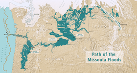
During the end of the Last Glaciation, when the last ice dam at the Clark Fork river let go, draining Glacial Lake Missoula of 500 cubic MILES of water, the resultant flood down the Columbia River and its tributaries raised the level of water in the Willamette Valley to just over 250 feet from one end to the other.

It was called Lake Allison [had to check my notes there]

Looks like it might have been a nice place for a shoreline cabin...

1616006997893.png

Willamette Valley fertility, like the Palouse silt, is in large part due to the largest freshwater flood scientifically documented in history. The ice floods started in Lake Missoula in Montana 12,000 to 15,000 years ago during the Pleistocene and flowed down through eastern Washington, bringing fertile soil to the valley as it flowed out the Columbia River Gorge. The narrows at Kalama, Washington, restricted the flow of water, causing it to back up and flood the Willamette Valley to a depth of 300 to 400 feet (91 to 122 m) above sea level as far south as Eugene. The Willamette Valley had multiple floods during the last ice age, possibly reaching 100 floods separated by centuries, to depths of 300–400 feet. If 300–400 foot-deep floodwaters descended on the valley today, in Portland (elevation 20 ft), only the tops of the West Hills, Mount Tabor, Rocky Butte, Kelly Butte and Mount Scott would be visible, as would the US Bancorp Tower (536 feet) and the Wells Fargo Center (546 ft). Newberg's elevation is 175 feet above sea level, Oregon City (138 ft), McMinnville (157 ft), Salem (154 ft), Corvallis (235 ft) and Eugene (430 ft), likely rising above all of them. The lake eventually flowed out and drained, leaving 180 to 200 feet (55 to 61 m) of layered sedimentary soils throughout the Tualatin, Yamhill and Willamette valleys.
 
Last Edited:
During the end of the Last Glaciation, when the last ide dam at the Clark Fork river let go, draining Glacial Lake Missoula of 500 cubic MILES of water, the resultant flood down the Columbia River and its tributaries raised the level of water in the Willamette Valley to just over 450 feet from one end to the other.
Does that mean anywhere in the WV that is below 450ft of elevation was under water?
 
Does that mean anywhere in the WV that is below 450ft of elevation was under water?

Just about everything - look at the map I posted, figure out where you live, and let me know. As my Masters was based mainly on the last Cordillerian Glacial Period and its resultant flooding, I'm interested to know.

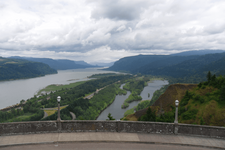
What piqued my interest in the period was standing in the car park at Crown Point, Oregon, and looking up the Gorge. Noting the numerous hanging valleys and their incredible waterfalls, like Multnomah, I got to thinking what the view might have been around 12500 years ago, when the last gasp of the last Glacial Lake Missoula flood came down the river, 500 feet high and travelling at 60 -70 mph, clearing away everything that isn't there any more.
1616012844875.png
Makes ya feel small, eh?
 
Just about everything - look at the map I posted, figure out where you live, and let me know. As my Masters was based mainly on the last Cordillerian Glacial Period and its resultant flooding, I'm interested to know.

What piqued my interest in the period was standing in the car park at Crown Point, Oregon, and looking up the Gorge. Noting the numerous hanging valleys and their incredible waterfalls, like Multnomah, I got to thinking what the view might have been around 12500 years ago, when the last gasp of the last Glacial Lake Missoula flood came down the river, 500 feet high and travelling at 60 -70 mph, clearing away everything that isn't there any more.
View attachment 844539
Makes ya feel small, eh?
And it ticks me off about it's leaving all those rocks I hit every time I put a shovel in the dirt here.:mad:
 

Upcoming Events

Redmond Gun Show
Redmond, OR
Klamath Falls gun show
Klamath Falls, OR
Centralia Gun Show
Centralia, WA

New Resource Reviews

New Classified Ads

Back Top